- Australian bushfires sparked in September have spread for months, leading to a state of emergency in many regions.
- As of the new year, the blazes have scorched more than 14 million acres of land, killed about half a billion animals, and displaced hundreds of thousands of people.
- The blazes are so large and widespread that satellites in space can easily photograph them from orbit.
- Specialized sensors on satellites that can see through the thick smoke are recording the bushfires’ spread.
- Visit Business Insider’s homepage for more stories.
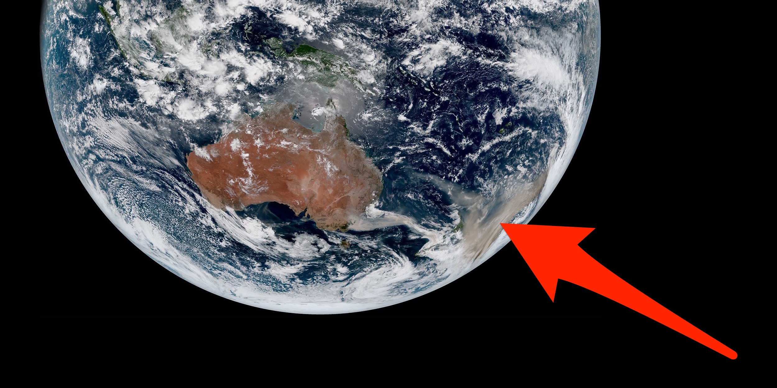
Australia’s raging bushfires are so bad that satellites thousands of miles above Earth can easily spot their flames and smoke from space.
The fires likely started naturally, though experts think human-caused climate disruption has exacerbated hot arid conditions that fuel the growth of such blazes. Current estimates suggest eastern Australia’s bushfire crisis has scorched more than 14 million acres of land, killed about half a billion animals, and displaced hundreds of thousands of people.
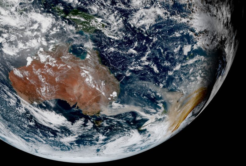
The photo above – which shows plumes of smoke about half the area of Europe darkening skies as far as New Zealand in a yellow haze – was taken on Thursday by the Japan Meteorological Agency’s Himawari-8 satellite.
Himawari-8 launched in October 2014 and weighs about as much as a Ford F-150 pickup truck. It now orbits over the same point about 22,300 miles above our planet. Using a variety of onboard sensors, Himawari-8, NASA’s Suomi-NPP satellite, and other Earth-monitoring machines are returning stunning imagery of Australia’s dire situation.
Here are some of the most revealing photos, animations, and illustrations of the crisis on Earth as seen from outer space.
Himawari-8 overlooks the Western Hemisphere and photographs this face of Earth once every 10 minutes. Australia, its bushfires, and smoke plumes are easily visible.

NASA's Suomi NPP satellite, which orbits about 500 miles up, offers a much closer view of the planet — though a less consistent one. Here, Australia's bushfires are shown picking up in November.

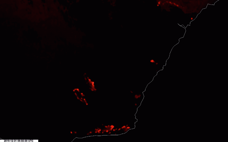
Redder and longer wavelengths of light, such as near infrared, can show fiery hotspots on the ground through the haze and smoke.

Embers from fires that began in September have spread easily in abnormally long, dry, and expansive drought.
![]()
This animation, from January 1 and 2, highlights multiple hotspots in normally invisible infrared light. Two especially large patches of bushfires (shown just southwest of the center) stretch dozens of miles long.
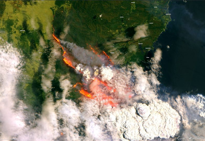
Daytime satellite views of the ground are equally, if not more, dramatic. The European Space Agency's Sentinel-2 satellite took this image of growing bushfires while passing over Bateman Bay on New Year's Eve.
Source: Twitter
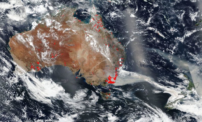
The scope of the fires is hard to comprehend. In New South Wales alone, blazes have created a fire front in the state that — if put into a straight line — would stretch from Sydney, across the Indian Ocean, and into Afghanistan.
Source: Twitter
The smoke plume alone is about 1.3 billion acres, or half the size of Europe, and is drifting more than 1,000 miles over New Zealand, where it is choking and yellowing the skies.
Source: Twitter
So far, the bushfires have chewed through more than twice the area that burned in Amazon's rainforests during 2019.
![]()
Source: Queimadas
At least 17 people have gone missing in the fires, eight have died, and hundreds of thousands have evacuated. Volunteer firefighters are working around the clock to curtail the disaster, though it may burn until cooler fall temperatures arrive in the Southern Hemisphere several months from now.

Aylin Woodward contributed reporting to this post.